
Leeds City Council (LCC) have launched its public consultation on its Local Plan. The Local Plan is a legal framework guiding all development and planning decisions in Leeds. It includes policies on housing, green space, climate, and land allocation, setting out the council's vision and strategy for the area until 2040-2042.
It ensures that development is considered in a way that meets the needs of the community and the environment.
It includes new housing allocations across the Outer North East area, which covers Wetherby, and could significantly shape development around the town.
Latest status: Public consultation open until 15 September 2025. Residents are encouraged to comment on the site assessments and highlight inaccuracies in the early-stage “desk‑top” review.
Leeds Local Plan Consultation
Proposed Strategic Planning Framework.
Quick Links
Documents & References
Better Wetherby’s View
Our Position
Better Wetherby supports planning that is evidence‑based, environmentally responsible, and aligned with genuine community needs. We recognise that some new housing is required across Leeds, but emphasise that:
Wetherby has already delivered more than its share of housing in previous plans.
Infrastructure considerations (roads, schools, healthcare, public transport) must be central to any decision.
High‑level site assessments contain errors and must be scrutinised — local knowledge is essential.
The volume of submitted sites risks distorting the picture; community input is needed to ensure the plan reflects reality.
Decisions must respect Wetherby’s unique character, green setting, and ecology.
We encourage residents to submit clear, constructive comments on the portal to help ensure the Local Plan accurately reflects the needs and constraints of our area.
Key Issues & Evidence
Planning Context
Outer North East (where Wetherby is located) has a defined housing requirement of 2,186 homes, of the 76,817 needed across Leeds. Submitted sites far exceed this (6× district‑wide oversupply). Wetherby has already more than met its previous housing targets according to LCC’s call‑for‑sites report.
Highways & Transport
Wetherby already faces congestion, HGV pressure, and limited public transport. Additional housing without infrastructure planning would worsen peak‑time traffic, road safety around local schools, air quality. Better Wetherby has repeatedly raised these concerns at LCC meetings and in deputations.
Environment & Ecology
Several submitted sites sit adjacent to green belt or sensitive landscapes. Wetherby’s surrounding areas include valuable habitats (e.g., newt breeding sites), farmland, and public green spaces. Risk of increased surface water and drainage challenges, especially where development sits above lower‑lying ecological features.
Community Impact
Schools in Wetherby are near capacity; no clear plan for expansion is included. Healthcare services are already stretched. Loss of green space affects wellbeing, recreation, biodiversity, and climate resilience. Retail and transport access must be considered holistically, not site‑by‑site.
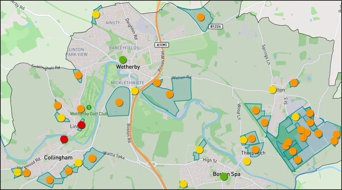
Visual Overview
Outer North East housing sites map
The consultation includes a map showing all submitted sites across Wetherby and nearby villages, coded using LCC’s high‑level assessment ratings:
Green – largely positive
Yellow – some issues
Orange – significant negatives
Red – serious concerns
Residents can click each site to view details and submit comments.
Sites north of the black boundary line fall under North Yorkshire, which will run its own future consultation